Shelly Bay.
The site of a former air force base it has a long military history beginning in 1886 when the Submarine Mining Depot was constructed there in response to the "Russian Scare" (no minefields were ever lain). The Navy took over these operations and the base in 1907. 1914 saw the construction of a number of munitions stores in the hills behind the base. In 1942 reclamation work was started in the northern bay to provide more flat land for the base, which had been renamed HMNZS Cook. The wharves were also enlarged that year and the bay was dredged. Than in 1946 it was taken over by the RNZAF, and renamed Shelly Bay Air Force Base. The base was used for administration and accommodation and was closed in 1995. Since 2008 it has been owned by the Taranaki Whanui as part settlement to a treaty claim. The old base buildings are now being used by various businesses including an art gallery, cafe, children's art centre, and a film studio. The wharves have been in disrepair for some time and are not in use. The long term future of the site is at this time unknown.
The 'Janie Seddon' and 'The Admiral' at Shelly Bay.
Gold Medal Series No.6903.
The Janie Seddon was a minelayer, and The Admiral a harbour ferry.
The Janie Seddon was a minelayer, and The Admiral a harbour ferry.
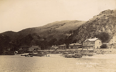
Karaka Bay.
Named after the groves of Karaka trees, planted by Maori, that grew in the area. The wharf here serviced both Scorching and Worser Bays, and horse carts went to both beaches, so for a fee, you didn't have to walk.
Karaka Bay. Tourist Series 2361. Frank Duncan & Co.
Karaka Bay, with Wellington Heads in distance.
Maoriland Postcard, Tanner Bros, 88-114.
Karaka Bay. F.T. Series No.416.
Panoramic View of Karaka Bay. Gold Medal Series No. 6906.
Karaka Bay, A Favorite Seaside Resort. Muir & Moodie, 1986P.
Picnic at Karaka Bay. Private card.
Karaka Bay. McClymont, 451.
'Mr & Mrs Blackman whare' in ink on back. Hut at top left?
The two story building is the tea rooms.
Karaka Bay. McClymont, M454.
Karaka Bay. McClymont, M456.
Karaka Bay. McClymont, 457.
Karaka Bay. McClymont, 458.
Karaka Bay. McClymont, 459.
Karaka Bay. McClymont, 460.
'Mrs Dougherty's house with tower' in ink on back.
Karaka Bay, 1912. No photographer ID, Private card?
Note tea rooms bottom right.
Worser Bay.
The site of a pilot station in the 1860's it was given it's name after pilot James Heberley's frequent comment that the weather was getting 'worser and worser'. The original pilot's cottage is still standing at the bay. The bay is the home of the Worser Bay Life Saving Club (1910), and the Worser Bay Boating Club (1926). If you didn't want to use the ferry to get to the bays, a horse coach went from Wellington to Seatoun via the Worser Bay hill, (Awa Rd). Worser Bay School at the top of the hill was the first on the peninsular. The Evening Post of 1896 had adverts for furnished seaside cottages for rent at the bay, with the "famous Whangatura-a-Tara mineral spring on the property". By 1906/7, Mr Robert Hearn and Mr Sampson Williams had built 9 more fully furnished three and four bedroom cottages for rent at twenty shillings per week. There was also a good dairy with goods at "town prices". The row of cottages, on both sides of the dairy in the middle, can be seen on some of these cards.
Worser Bay. Industria series, No.5844, Fergusson Ltd.
Worser Bay. Gold Medal Series, No.15844, Fergusson Ltd.
Worser Bay. A3718.
Worser Bay. No.1518
Submarine Explosion at the Worser Bay. Littlebury's Series.
After the explosion there was a dead fish collecting competition.
This card, and the four below, at the Anniversary Day Miramar Seaside Carnival, 22 Jan, 1908.
Worser Bay. G & G Series 121.
Worser Bay. F.T.Series No. 2258A
Worser Bay. No photographer or publisher.
(Note 'The Kiosk" sign on the hill.)
On the Beach at Worser Bay. Littlebury's series No.120.
Worser Bay. "Zak" 737.
Scorching Bay.

Scorching Bay. Maoriland, Tanner Bros, 306.
Worser Bay. "Zak" 737.
Scorching Bay.

Scorching Bay. Maoriland, Tanner Bros, 306.
Scorching Bay. No 4729.
Karaka Bay. Tanner Bros No.145.
The card says Karaka, but this is Scorching Bay.
Karaka Bay, 'New Years Greetings'. F.T.Series, No. 376.
Again shows Scorching Bay.
Mahanga Bay.
North of Scorching Bay, Mahanga Bay has a long history of military use. The wharf there was probably built about 1885-86 to bring ashore materials for the construction of Fort Ballance, and later used for supplies and landing troops. At this time most of Miramar North was military reserve and closed to the public. The Mahanga Bay wharf was demolished in October 1962 after being abandoned for many years. Today the bay is used by a NIWA research laboratory.
Engineers at Mahanga Bay, (The Signaling Corps) 25.1.08 "Zak" 502.
Breaker Bay.
Access to Breaker Bay was at first only from Seatoun, over a rough track where the Pass of Branda is today. This track lead to a quarry where stone was dug for forming many of Miramar's roads. There are a number of bays along this coast, Eve, Flax, Reef, and Palmer Bays, which are now all generally called Breaker Bay. Over time some baches and cottages were built along this rough coast, with many builders having to remove rock from the cliff face to create a flat site. In 1924 there was a large sale of sections, and the track was extended as far as Palmer Head.
Breaker Bay, 1002. F.G.Barker photo. Tanner Bros. Maoriland Series.
Breaker Bay. Royal 1130.
At the Harbour Entrance.
Publicity Dept photo 2946. Tanner Bros Maoriland Photographic Series.
Breaker Bay.
Tourist Series 361. Frank Duncan & Co.


No comments:
Post a Comment